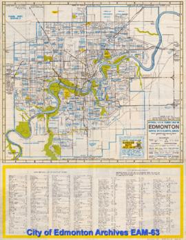
Small figures in red indicate House Numbers, Street Railway in red, Public Parks in green, Jasper Avenue & First Street shown to large scale on either side of map.
Includes part of Bylaw 3100 Truck Routes, and information on truck routes on verso.
This map was printed for the visitors during Commonwealth Games, and includes information about the event as well as various points of interest.
This map is part of a pamphlet titled "The City of Edmonton Street Map and Tourist Information Guide". The map includes hospitals, parks, places of interest, tourist attractions, subdivisions, streets, swimming pools, and land subdivisions. The other side contains general tourist information.
This map includes land ownership, roads, sections, places of interest, tourist attractions, and bodies of water. This map is part of a double-sided brochure titled "Strathcona". It also includes a map of Sherwood Park, and visitor information about the Count of Strathcona.
The verso includes a map of points of interest and a detailed map of downtown Edmonton, as well as tourist information.
This map depicts transit routes and schedules.
This map is part of a two-sided pamphlet providing information on snow removal in Edmonton.
This map includes four historical walking tours of downtown, including Heritage Trail, Jasper West and Warehouse District, Downtown and Rice Howard Way, and Jasper East.
1996-97 Edition. Verso includes maps of Morinville, Stony Plain, Spruce Grove, St. Albert, Leduc, Fort Saskatchewan, Sherwood Park, Beaumont, and Devon.